
Hiking routes
The best hiking routes in l’Estartit – Torroella de Montgrí for all ages and tastes
The natural environment of l’Estartit and Torroella de Montgrí offer endless possibilities of routes and itineraries for hiking. Whether you are on holiday as a couple, with friends, with your family or you just want to disconnect on your own and lose yourself in the landscapes of the Costa Brava, there is an option for everyone.
With all ages and tastes in mind, we recommend a selection of hiking routes in order of difficulty:
Low difficulty: The windy route
The windy route owes its name to the fact that it is highly exposed to the tramuntana, so it is advisable to cancel it if a cold and turbulent wind is forecast.
It is a circular route, in the shape of an eight, which has a maximum duration of two hours, with a distance of 6.50 km and a slope of 50 metres. It is not difficult, so it can be done even with the youngest children. It is advisable to bring water, as there are no public fountains along the way, and if it’s done in summer, bring protection and avoid the sunniest hours, because there are no shaded areas.
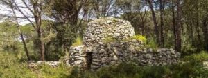
Heirs' Hut
Medium difficulty: Route to Cala Montgó
Route to Cala Montgó is a linear route that links the seafront promenade of l’Estartit with the spectacular Cala Montgó.
As it is a linear route, the return journey can be made on the same route as the outward journey or by transport. The time to reach the destination is approximately three hours, not including the time to return to the starting point. The route has a gradient of 179 metres and a distance of almost 9 kilometres.
Apart from being a route with quite steep and rocky trails, we warn you that there are many points without coverage, so we recommend knowing the route in advance, carrying an analogue map and taking into account that it will be a virtually offline journey.
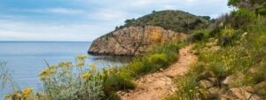
Views of the Punta del Milà from the Crestats
High difficulty: Tour of the area of l’Escala
Tour of the area of l’Escala, discover the treasures of the coast and inland of the municipality of l’Escala with this hiking route of high difficulty.
With an approximate duration of 5 hours and 12 minutes, a difference in altitude of 133 metres and a total distance of 18.20 kilometres, the Volta al terme de l’Escala route is the most difficult in the area.
The route runs along tracks, paths, cliffs and the seafront promenade, and there is the option of taking a break for lunch along the way, as there is an area equipped with picnic tables in Horts d’en Roure.
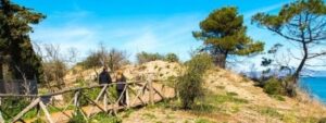
Coastal dunes on the Moll Grec beaches
We hope that these hiking routes have served as inspiration for you to organise the days of your stay in our flats. We also recommend the free NaturaLocal app for Apple and Android devices, to download the guided and interpreted route, with all the information at your fingertips for the option you choose.
To download from the App Store click here.
To download from Google Play click here.
